| Overview | |
| Science | |
| Data | |
| Movies | |
| |
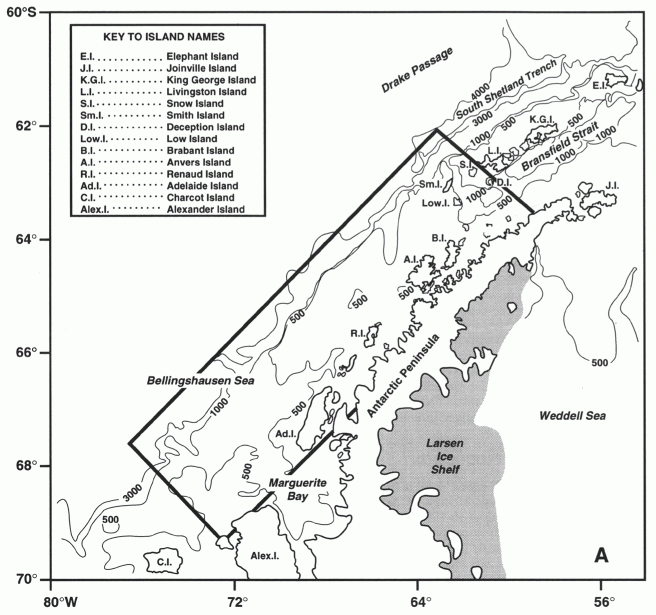
| Science Lagrangian near-surface current observations on the western Antarctic Peninsula shelf: results from the Palmer LTER 2005-2006 drifter study Abstract We deployed 16 satellite-tracked near-surface drifters during the annual austral summer Palmer Long-Term Ecological Research (LTER) program cruise in January 2005 and again in January 2006 to investigate the near-surface Lagrangian currents over the Western Antarctic Peninsula (WAP) shelf between 63 and 68 S. Past LTER cruises have collected much valuable hydrographic and biological data in this area, but before 2005, there have been very few direct measurements of currents. Sea ice usually covers the entire region from June to December. The primary goal of these drifter deployments was to develop a better understanding of the regional circulation in the LTER study area through direct Lagrangian current measurements. The 2005 drifter trajectories can be characterized by four separate circulation patterns: 1) northeastward flow (in the Antarctic Circumpolar Current) offshore of the 1000-m isobath at speeds up to 1.1 m/s; 2) southeastward flow over the mid- and inner shelf towards Adelaide Island and into the low-salinity Adelaide Island Coastal Current (AICC) that flows southwestward along Adelaide Island and into Marguerite Bay at speeds up to 0.5 m/s during periods of no sea ice; 3) cyclonic (clockwise) circulation over the inner shelf north of Adelaide Island between the coastal current and the offshore northeastward circumpolar flow; and 4) weak flow toward the northeast over the inner shelf north of Adelaide Island. These flow patterns result in a flow divergence over the mid- and inner shelf located at about 65 S. Island tends to separate the shelf from the coast, forming an inner passage along the coast that is connected to the shelf through several straits and passages. Background The Palmer LTER Program The Palmer LTER program was started in 1990 by the National Science Foundation Office of Polar Programs to investigate the marine ecosystem on the western Antarctic Peninsula (WAP) shelf and its sensitivity to climate change and sea ice variability on season to inter-annual and decadal time scales (Smith et al, 1995). Long-term air temperature measurements at the British station Faraday (65.25? S, 64.27? W) plus shorter records at the British station Rothera (Adelaide Island) and Palmer Station show that the highest warming trends in the entire Antarctic occur in the LTER study area (Smith and Stammerjohn, 2001). In particular, while there is large inter-annual variability, these records show that the yearly mean (and especially the winter minimum) air temperatures are rising at a rate of roughly +0.06 ?C per year. Ecosystem responses to the rapid warming and sea ice decline are already apparent at all trophic levels from phytoplankton to penguins (Smith et al., 2003). The Palmer LTER study area includes Palmer Station, where year-around studies can be readily conducted, and extends along the shelf towards the southwest to Marguerite Bay (Figure 1). The shelf bathymetry in this area is quite variable, with an average depth of order 400 m, numerous banks and deeper channels, and a shelf break at roughly 500 m. A line of islands stretching southwest from Palmer Station on Anvers Island to Adelaide Preliminary Results - August 2004 The following distribution plots are preliminary:
Figure 1 Map of the western Antarctic Peninsula (WAP) shelf region. The bottom contours are given in m. The rectangle shows the PAL study region. (Figure from Hofmann and Klinck, 1998) Cetaceans We anticipate encountering these species during the August 2004 cruise: |