| Overview | |
| Science | |
| Data | |
| Movies | |
| |
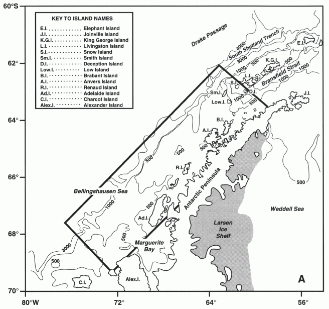
| Science The U.S. GLOBEC Southern Ocean (SO GLOBEC) program is a collaborative effort designed to study physical and biological factors that contribute to the enhanced growth, reproduction, recruitment, and survivorship of Antarctic krill (Euphausia superba) on the central Western Antarctic Peninsula (WAP) shelf Abstract Abstract We deployed 24 satellite-tracked surface drifters near Marguerite Bay on the West Antarctic Peninsula shelf during the 2001 and 2002 austral summers. The WOCE-style drifters featured holey sock drogues centered at 15 m and were located about 20 times per day by Service ARGOS. Analyses of the drifter tracks show a coastal current that flows toward the southwest along the west coast of Adelaide Island and into Marguerite Bay near the southern tip of Adelaide Island, then flows clockwise around the Bay near the coast, and finally exits the Bay near Alexander Island. This coastal current flowed along the eastern boundary of Marguerite Bay in 2001, but across the central part of the Bay in 2002 due to the early presence of sea ice in the southern half of the Bay. The outflow from the Bay continued along the coast of Alexander Island toward the southwest in 2001, but was directed northwestward across the shelf in 2002 because of the sea ice presence. A mean drifter current speed of about 10 cm/s was observed in the coastal current with a maximum speed of about 20 cm/s during periods of strong wind stress. An intermittent northeastward current was observed near the shelf break. The drifter tracks also show that intermittent near-inertial currents are common in Marguerite Bay and over the adjacent shelf during ice-free conditions. These counterclockwise oscillations had periods near the local inertial period (roughly 13.0 hrs) and speeds of 5-20 cm/s, with a tendency for smaller amplitudes within Marguerite Bay. Background The SOG Drifter Program The bathymetry in the SO GLOBEC study region is quite variable, especially within Marguerite Bay where many shallow reefs and small islands occur in addition to a deep trough (Fig. 1) (Hofmann et al., this issue). The average bottom depth over the shelf is roughly 460 m, while the mean depth of the shelf break is about 500 m. A deep channel starting near the shelf break runs southeastward across the shelf off Adelaide Island, crosses Marguerite Bay, and continues southward around Alexander Island as George VI Sound. The maximum depth of this channel is roughly 1500 m, located within Marguerite Bay near Alexander Island. The presence of this channel plus several shallower cross-shelf channels and distinct protrusions of the shelf break are thought to influence the regional circulation (Klinck et al., this issue). Recent hydrographic data provide a clear picture of the seasonal evolution of stratification over the central WAP shelf region (Hofmann et al., 1996; Smith et al., 1999). An on-shelf flow of Upper Circumpolar Deep Water (UCDW) from the ACC maintains a relatively warm, salty, nutrient-rich lower layer over the shelf beneath an upper layer of relatively cooler, fresher Antarctic Surface Water (AASW). The two layers are separated by a permanent pycnocline, centered between 150 m and 200 m, which provide a vertical flux of heat and salt into the upper layer (Klinck, 1998; Smith and Klinck, 2002). Over much of the shelf, net surface heating in austral spring through fall (~ +80 W/m2) warms the upper water column to depths of 50 to 100 m, while increased wind mixing, surface cooling (~ -80 W/m2), and brine rejection during ice formation in fall through winter creates a 100-m deep surface mixed layer. In comparison, our present knowledge of flow over the WAP shelf is quite limited, being based primarily on one FGGE drifter track from 1979, limited drifter deployments in the Bransfield and Gerlache Straits further to the northeast (Zhou et al., 2002), recent hydrographic data (Hofmann et al., 1996; Hofmann and Klinck, 1998), incomplete knowledge of regional wind forcing, and regional tidal models (Padman et al., 2002). The FGGE drifter moved northeastward along the shelf break during austral spring, then crossed the shelf near 65.5°S and moved southwestward to Adelaide Island in summer (mean speed 6 cm/s) before failing. The mixed layer drifters deployed in the Bransfield and Gerlache Straits exhibited a regional northeastward current along the deep channel to the southern continental margin of the South Shetland Islands and cyclonic eddies over the deep basins. The 1993 summer and fall salinity sections off Adelaide Island show a coastal band of fresher (lighter) water, which increased in depth, width and salinity contrast into fall, when it extended to roughly 50-m depth and 70 km offshore with a salinity difference of 0.5 psu from adjacent water (Smith et al., 1999). These observations suggest the formation of a buoyant coastally-trapped current near Adelaide Island during spring and summer melt, which continued to strengthen into fall towards the southwest. NSCAT-derived monthly mean winds over the Marguerite Bay/WAP shelf region were southwestward from spring into fall during ice-free conditions (Caruso, personal communication). These down-welling favorable winds should help drive and maintain a coherent buoyant coastal current along Adelaide Island during these seasons. Preliminary Results - August 2004 The following distribution plots are preliminary:
Figure 1 Map of the western Antarctic Peninsula (WAP) shelf region. The bottom contours are given in m. The rectangle shows the PAL study region. (Figure from Hofmann and Klinck, 1998) Cetaceans We anticipate encountering these species during the August 2004 cruise: |