 |
|
|
|
 |
|
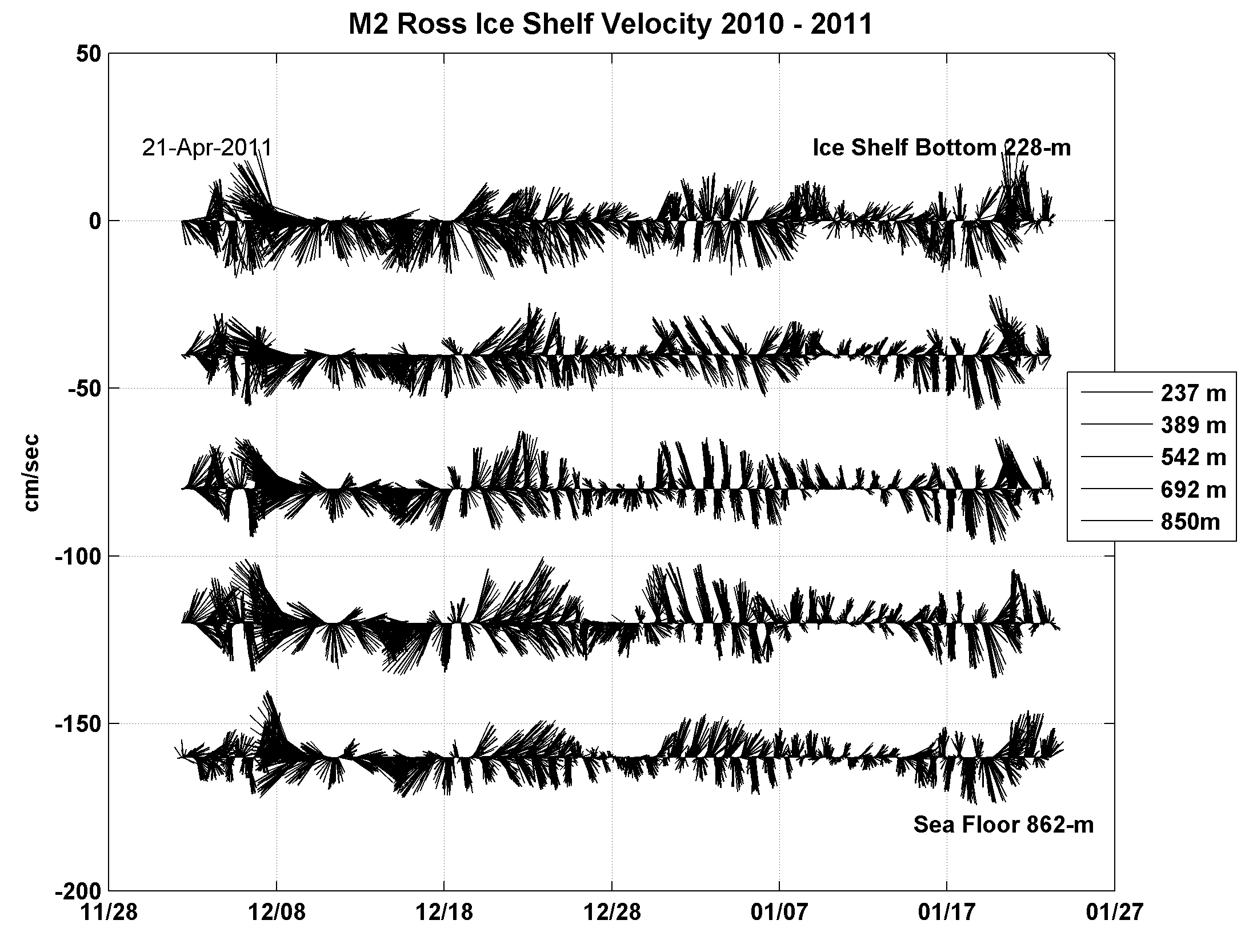
Figure 1- Velocity stick plot from under the Ross Ice Shelf (RIS) at the Coulman High site 16 km south of the northern ice edge. |
|
 |
|
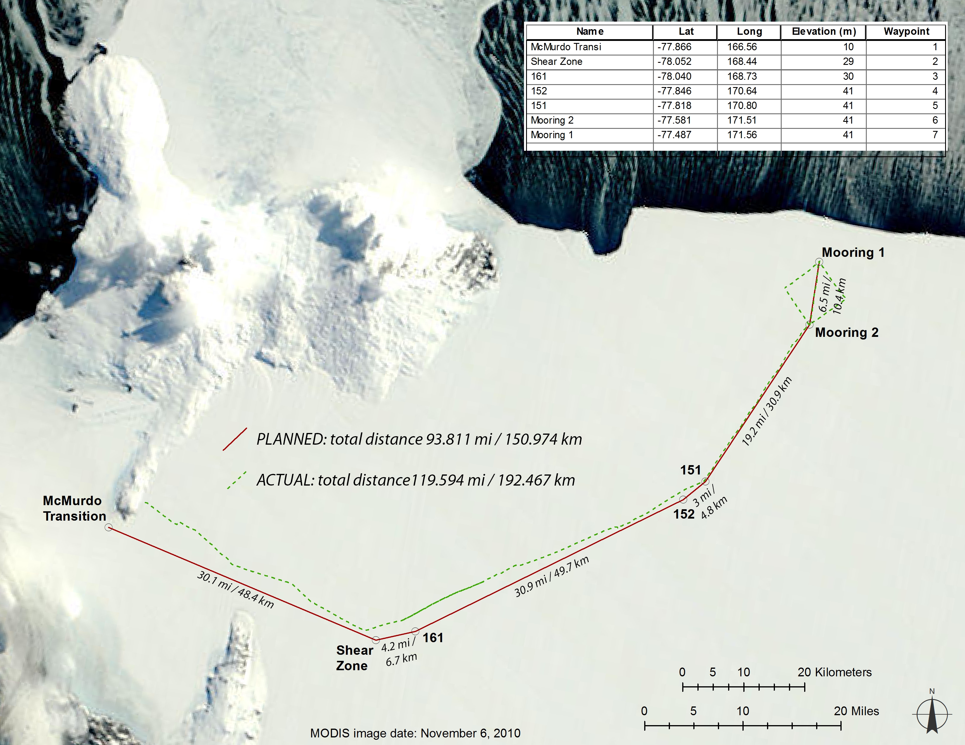
Figure 2- Location of the Coulmam High (CH) Moorings 1 & 2 near the northern edge of the Ross Ice Shelf, 130 km northeast of McMurdo Station, Ross Island, Antarctic. Figure 4 shows the traverse made in October 2010 to build the access road and supply the remote field camp on the Ross Ice Shelf. The satellite (MODIS) image November 6, 2010 shows open water polyna near the moorings on the edge of the ice shelf and solid sea ice extending north from Ross Island. |
|
 |
|
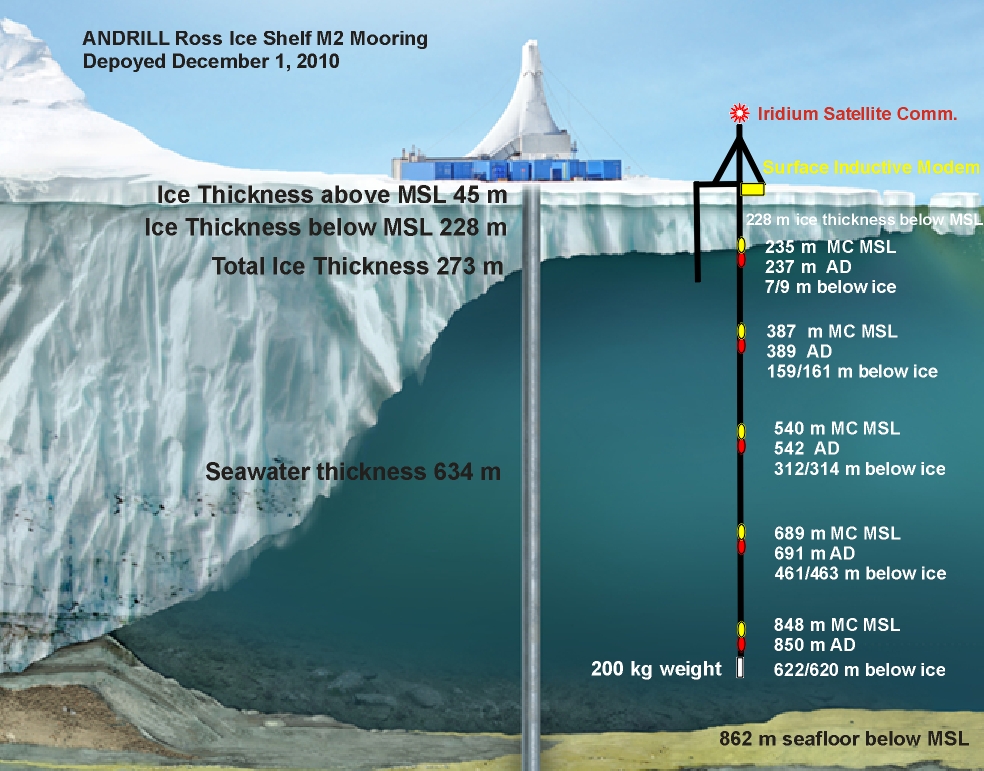
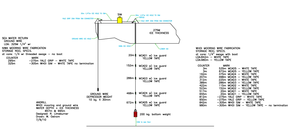
Figure 3 - Conceptual design of the 2010 Coulmam High Mooring. |
ANDRILL - Ross Ice Shelf Observatory 2011 - First time Velocity and Water Properties under the ice at Coulman High. This mooring was recovered January 23, 2011.
Brief Outline
This webpage documents the first moored real-time observations of velocity and water properties from a mooring deployed through the Ross Ice Shelf (RIS) at the ANDRILL Coulman High (CH) drill sites and also presents real-time data observations. The moored velocity and pressure, temperature, conductivity (PTC) observations are in support of the ANtarctic geologic DRILLing (ANDRILL) program, an international NSF supported program designed to investigate Antarcticas role in global environmental change (Rack, 2010). Drilling of sediment cores is planned by ANDRILL at Coulman High in 2013-14 to obtain records of historical climate change on the Antarctic continental shelf. The current meter mooring data shown here will provide direct input to the engineering design of the future drill structures.
This Woods Hole Oceanographic Instition (WHOI) research program is primarily intended to support the operational needs of the ANDRILL program by measuring currents and water properties under the RIS. The RIS field program presents a valuable opportunity to investigate processes under the ice shelf. In particular we will focus on the following aims:
- Assess the tidal, seasonal and interannual variability of the water column structure and transport across the ice front, including influences on and response to ice shelf basal melt, sea ice formation and variability of the Ross Sea Polynya;
- Characterise the under-ice-shelf boundary layer, the heat transport across this layer, and scales of vertical mixing throughout the water column.
Two current meter moorings were deployed near 77° 26.211'S, 171° 32.391'E on November 24 and December 2, 2010 through the RIS by Richard Limeburner and Will Ostrom (WHOI), Craig Stewart and Mike Williams (National Institute of Water and Atmospheric Research, NIWA), and Sanne Maas (Victoria University, Wellington, NZ). The WHOI mooring is located at the Coulman High site approximately 77 nautical miles east northeast of McMurdo Station, Antarctica. The RIS mooring sites are normally covered with ~275-m of freshwater ice (Figure 4). Five Nortek Aquadopp and five SeaBird Microcat inductive modem instruments were placed in the water column at 5 levels below the ice shelf. A surface inductive modem logger and Iridium satellite communication package were installed on the ice shelf upper surface at the WHOI mooring. The mooring was planned to be recovered in January 2012, but a Rapid proposal to extend the measurements for 14 months was declined. Recovery is unfortunatey now planned for late January 2011. The edited real time moored data will soon be presented here and a full analysis will be done in early 2011.
Deployment
The first real-time velocity and water property data from under the Ross Ice Shelf (RIS) at the Coulman High site approximately 16 km south of the northern ice edge. A local magnetic variation of +134° (East) was applied to the current meter data to obtain true north. Five Nortek AquaDopp current meters and five Sea Bird Microcats with inductive modems were deployed below an ice surface controller/logger/Iridium modem/antenna with special lithium batteries and heat pads - all packed inside 20 cm of rigid foam insulation. The lower boundary of the RIS was at a depth of 228-m below Mean Sea Level (MSL) and 273-m below the upper RIS boundary (air/firn snow interface) at the M2 mooring site. We deployed the M2 mooring on December 1, 2010 during a blizzard, but we worked inside the ANDRILL Hot Water Drill (HWD) protective structure shown in the photos.
The M2 mooring was designed and built with lithium batteries and 14 battery heater pads and an advanced electronic heater tcontroll system for a 14 month deployment by R. Limeburner, Will Ostrom and Jeff Obrien from Woods Hole Oceanographic Institution (WHOI) and Bruce Magnell, Archie Todd Morrison, and Minhchau Hung Vu from the Woods Hole Group (WHGrp), Falmouth, MA, USA.
Mooring Recovery
This functioning mooring was recovered January 23, 2011.
Acknowlegements
Thanks to Will Ostrom for successfully planning and deploying the moorings and making this whole operation successful and safe. Craig Stewart, Mike Williams and Sanne Maas were especially helpful with all the mooring deployments. A special thank you to engineers Bruce Magnell, Archie Todd Morrison and MinChau Hung Vu from the Woods Hole Group and Jeff Obrien from WHOI who superbly designed the electronic logger/inductive modem/Iridium satcomm/battery heater components of the Ross Ice Shelf mooring in a relatively short time. Thanks also to the entire Coulman High ice camp community of Tamsin Falconer, Richard Levy, Hedley Berge, Tristan Bennett, Jeremy Ridgen, Wallis Wood, Frank Rack, Rusty Freeman, Daren Blythe, Dar Gibson, Robin Bolsey, Graham Roberts. Finally, thank you Hedley for digging up the buried electronics and resetting the heater circuity on December 18, 2010.
Recent Events
PBS television ANDRILL documentary December 28, 2010. Is Antarctica headed for a catastrophic meltdown? New evidence of ancient climate change may hold clues. NOVA: Secrets Beneath the Ice is a production of NET Television.
In addition, there are a series of 5 related short videos produced by the Nebraska PBS team on the same subject.
This project is funded by the National Science Foundation.
Website by Richard Limeburner and updated
Feb 14, 2016, Tuckernuck Island, MA
rlimeburner@whoi.edu
To see a Video of an Auckland bungy slingshot, click here.
|
|
|
 Matapouri, NZ