|
|
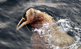 | | This young walrus was our companion for the entire afternoon and evening. |
| Click
to enlarge |
Daily Update
Calendar
Dispatch 21 - September 30, 2003
By C. A. Linder
Weather conditions: Overcast skies, 5 kt winds, calm seas,
air temperature 31°F
An Unexpected Visitor
All Marshall Swartz wanted to see on this cruise was a walrus. Today
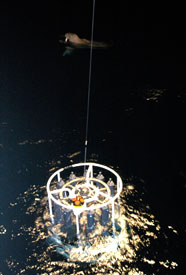
he got his wish, and then some! For the last six CTD casts of the
day, a young walrus turned up and entertained us with his antics.
Like an expectant puppy, he followed our ship from station to station.
Even though he couldn't match the ship's speed, he caught up every
time we stopped for a CTD. He circled the ship, eyeing us -- could
it be -- with amusement? Even as darkness
fell, Marshall and I remained on the fantail, unable to pull ourselves
away. The walrus pirouetted in the water and put a flipper up to
his head. Marshall did his best walrus calls, and while I'm not
sure what he said, I think the walrus understood because he grunted
and snorted back at us from the water. We were broken hearted every
time the CTD came back on deck and it was time to leave our friend
behind.
Mrs. Cadwell, a fifth grade teacher at Varnum
Brook Elementary School in Pepperell, Massachusetts, has
some questions about seafloor mapping. In her math class, she is
teaching her students how to chart the ocean depths. For a great
essay on the operation of depth-finding sonars, by mapping expert
Val Schmidt, read yesterday's dispatch.
Question: The shelf you are placing the moorings
on, how far is it from the actual slope?
Answer: Click here
to see a cross-sectional view of the mooring locations. The shallowest
WHOI mooring is in 57 meters of water, on the continental shelf.
This is the broad, flat plain stretching out from the shore. Moving
offshore, the next bathymetric feature we encounter is the shelfbreak.
The shelfbreak is defined as the point where the flat continental
shelf begins to "drop off." Looking at the plot, you might
guess that the shelfbreak is between mooring numbers five and six.
In actuality, if you take a closer look at the plot, the first break
(although not as steep) is between moorings one and two. The region
just offshore of the shelfbreak is known as the continental slope.
The rest of the moorings, from two to eight, are all on the continental
slope. The continental slope gradually becomes less and less steep
until it becomes the "continental rise." When the bottom
becomes completely flat again, we have reached the abyssal plain.
Question: How far down does the slope go?
Answer: The slope ends at the edge of the Canada
Basin; the depth there is roughly 3,800 meters (12,500 feet or 2.4
miles!) This is one of two deep arctic abyssal plains - the other
is the Eurasian Basin, on the European and Russian side of the Arctic.
Question: At what degree?
Answer: The average angle of the slope, from shelfbreak
to continental rise, is 4%. While this may not seem very steep,
remember that this is the average slope over 60 kilometers. Certain
segments of the slope are steeper than others. The steepest angle
along the entire slope is 23%! As a reference, the New Hampshire
Mount Washington auto road grade is 11%. If you've ever driven (or
run or hiked) up the tallest peak in New England, you can appreciate
just how steep 11% is!
Tomorrow is show time for the WHOI mooring team. The deepest mooring
will be redeployed immediately after breakfast. Thanks to Ryan Schrawder's
efforts (including some technical support via satellite phone!), the
moored profiler is ready to go to sea. We also plan to deploy one
of the three Acoustic Recording Packages.
 Previous
Dispatch Next Dispatch Previous
Dispatch Next Dispatch

Back to
Calendar
|