|
Daily Update
Calendar
Dispatch 20 - September 29, 2003
By C. A. Linder
Weather conditions: Overcast skies, 5 kt winds, calm seas,
air temperature 31°F
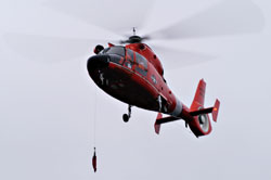 | |
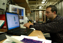
| The aviation detachment
practiced some drills today. Here they lower a sling, which
is used to pick someone up out of the water in an emergency. |
| Click
to enlarge |
Edge of the Arctic Shelf
Well, last night's red sky didn't exactly
bring us a "sailors' delight" in terms of weather... Ominous
overcast skies and the occasional sleety rain heralded another gray
day in the Beaufort Sea. The poor weather didn't stop the Healy's
aviation detachment from running a number of training flights this
morning, though. They practiced lowering
a sling onto the deck - this is how they would hoist someone out
of the ocean in a rescue situation. Crew members also got rides in
the helicopter during the training flights as a morale boost.
It was another full day of preparation for the mooring team. After
lunch, Ryan Schrawder tested two acoustic
releases at 6,000 feet to make sure they were operating properly
at depth. Even though they all worked fine during the recovery,
it never hurts to double check. Meanwhile, John Kemp measured
out the proper amount of line for the deepest mooring, cut it
to size, and added the connectors that join it to the rest of the
mooring chain.
Since the WHOI mooring array
is sited on the edge of a steep
submarine cliff, proper positioning of the moorings is critical.
Each mooring is very precisely measured - if you put one in water
that is too shallow, then the top of the mooring could hit the ice
keels in winter.
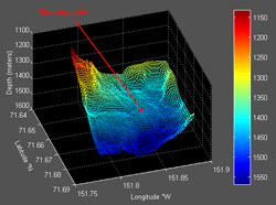
Val Schmidt from the Lamont-Doherty Earth Observatory
of Columbia University in New York is the seafloor mapping expert
on our science team. He uses data from the ship's acoustic depth-finder
to make detailed bathymetry charts (maps of the ocean bottom). I asked
him to explain how the depth-finder works and how he makes use of
the bathymetry data.
"Multi-beam sonar of the type installed on the Healy
is used for surveying the ocean floor. It's called a "swath
mapping" sonar system, as it maps out a large stripe, or swath,
of the ocean floor beneath the ship as we drive along.
The sonar consists of two large transducer arrays on the bottom of
the ship. The "projector" sends out pulses of sound into
the ocean, while the "receiver" listens for the echo produced when
the sound pulse bounces off the sea floor. We measure the time difference
between each ping and echo to calculate the distance to the bottom.
It would be an easy calculation if sound traveled in a straight line
in the ocean (If you drive 60 miles per hour down the highway for
an hour, you've gone 60 miles.) But temperature, salinity (how much
salt) and pressure (the water depth) all cause changes in the speed
that sound travels in water, and these speed changes cause bends in
the sound's path. So we have to know how the speed of sound changes
through the water column all the way to the bottom, and we measure
this periodically with data from the CTD or an expendable probe. Then
with some fancy math we can calculate the correct distance to the
bottom taking all this into account.
By using an array of projectors instead of just a single one, we can
measure this distance in up to 120 places beneath the ship with a
single ping! After driving back and forth "mowing the lawn,"
we can collect data from many many pings, and create a three
dimensional surface of the sea floor topography.
Lately, we've been surveying the edge of the continental shelf where
we will deploy 8 moorings in the coming days. The sonar allows us
to locate relatively flat places on which to anchor the moorings.
The drop off the continental shelf is akin to the Appalachian mountains.
It is important to find a stable location to anchor the instruments."
Late tonight we suffered a minor setback - Ryan Schrawder discovered
a problem in the electronics of one of the moored profilers. This
means another day of testing and communication with the manufacturer.
While we're not happy about waiting another day to deploy the moorings,
the proper performance of the instruments is critical to the data
quality.
 Previous
Dispatch Next Dispatch Previous
Dispatch Next Dispatch

Back to
Calendar
|