|
|
 |
Daily Update
Calendar
Dispatch 28 - September 28, 2004
By C. A. Linder
Weather conditions: Mostly cloudy skies, snow showers, 20-30
kt winds gusting to 35 kts, 8-12 ft seas, air temperature 31░F
Behind the Scenes
A hint of blue in the sky this morning
was a welcome relief from the past two days of heavy overcast. It
was a sign of a change in the weather. We all breathed a collective
sigh of relief that the wind had died down considerably. While still
a chill blast at 20-30 knots, it's nothing compared to the 47 knots
I saw on the anemometer before I went to bed last night. By mid-afternoon,
the seas had abated to the point where safe CTD
operations could resume.
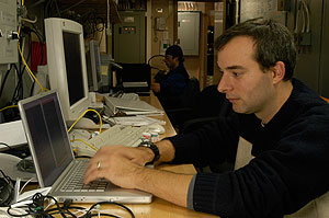
I would like to take this opportunity to thank Grant Massey, Val
Schmidt, and Ethan Gold, who have been working long hours to keep
our communications flowing and our data secure. Their behind the scenes
work may not be glamorous, but we all appreciate their efforts immensely.
Thanks guys!
To get an idea of what kind of responsibilities they have onboard, I asked them to answer a few questions.
How much data have we collected so far on this cruise? What
kind of things are you archiving?
Val: So far we have over 35 gigabytes of data--that's
enough to fit on 6 DVDs or 50 CD-ROMs. Most of the data is sonar data.
We record the bottom depth continuously using mapping sonars. That
data alone takes up about 2/3 of the total data volume to date. The
other large data set we call the "underway data." This is everything
from air temperature, wind speed and direction, barometric pressure,
various records from as many as 5 GPS receivers (position, speed,
time etc.), sea water temperature and salinity, bottom depth, etc.
Most of these are recorded once a second. With 86,400 seconds in the
day, it adds up."
Grant Massey is a systems engineer who works with the Healy's Information
Technology petty officers to keep our communications flowing with
the outside world. We currently are enjoying two one-hour
periods of internet use. You may be asking--how on earth can we get
an internet connection in the Arctic Ocean?
Grant: "Our Internet connection is not like connecting
from home. We need to connect via satellites. Since the satellites
are so far south of our location our dish points south just above
the surface of the ocean until it reaches the satellite somewhere
over the Pacific. It then is sent to an earth station in New Zealand.
From there it goes back up to another satellite and is sent to San
Diego, California where it travels via a land line to our home port
in Seattle where it is finally connected to the rest of the internet.
The whole ship is serviced with a 64 KB connection, which is less
than the dial-up rate that most homes use today. We actually get a
lot lower bandwidth due to lost packets and retransmissions of the
missing packets. All this is done so we can receive E-Mail and occasionally
view our favorite web sites."
I have just received a new batch of questions from Mrs. Lyons'
fifth grade class at Mount Alvernia Academy in Chestnut Hill, Massachusetts.
Thanks for your questions--I will be answering them in these last
four dispatches.
Vanessa: How close to the North Pole are you?
Answer: We are currently at a latitude of 70.5░N.
The North Pole is about 1300 miles away. That's comparable to the
distance from Boston to Cuba. At our farthest north point, 77░ 8.4'N,
we were still nearly 900 miles from the North Pole.
|
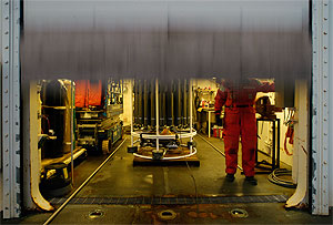 |
| Marine Science Technician Ian Fallon opens the wet lab garage door for a CTD cast. |
Click to enlarge
|
Devin: What causes the Northern Lights, and why is it that
we can't see them in Massachusetts?
Answer: Hi Devin. For a detailed discussion of what
causes the Northern Lights, check out this earlier
Dispatch. To see photos of a beautiful aurora event from earlier
in the cruise, click here. Regarding
your second question--you can see them in Massachusetts, just not
that frequently. The last time Massachusetts had a major aurora display
was Halloween night, 2003. It was the result of a large solar flare.
The auroral oval is centered around the geomagnetic poles. Thus, the
strongest and most brilliant northern lights are seen along this band,
which circles the northern arctic tundra. When the sun releases an
abnormally large wave of particles, however, the aurora borealis can
be seen as far south as Mexico.
Dimitri: How cold is it and what time does the sun set there?
Answer: The temperature has been fairly constant
out here at right around freezing (32░F). The coldest it got was 17░F,
when we were at our farthest north position in the icepack. Sunset
today was at 8:35PM Alaska time, and it's getting earlier by about
six minutes every day.
As I finish this dispatch, we are progressing along our central channel CTD section. First item on the agenda tomorrow morning is the last mooring recovery. After that we'll be completing a few more CTDs and then heading for Nome.

|
Traducido al Espa±ol por
Andrea
|
Detrßs del escenario
Se insinuaba un azul en el cielo de esta ma±ana nos daba un respiro de los ultimos dos dias de dura tormenta. Era una se±al de que el timpo habia cambiado. Todos respiramos tranquilos cuando vimos que el viento se tranquilizaba considerablemente. Aunque aun tenemos unas frescas rafagas de 20-30 nudos, no es nada comparado con los 47nudos que vi en el anemometro antes de que me acostara anoche. A media tarde el mar amaino hasta tal punto de que las operaciones de la CTD se pudieron realizar.
Me gustaria aprovechar la oportunidad para dar las gracias a Grant Massey, Val Schmidt, y Ethan Gold que han trabajado muy duro para mantener nuestras comunicaciones fluidas asi como los datos seguros. Su trabajo tras el escenario puede no ser glamuroso, pero todos apreciamos su inmenso esfuerzo. ĪGracias chicos!
Para hacernos una idea del tipo de responsabilidades que tienen abordo, les hice algunas preguntas.
┐Cuantos datos habeis recogido hasta ahora en la campa±a?
┐Quķ tipo de cosas estais archivando?
Val: Hasta ahora tenemos sobre 35 gigabytes de datos,
suficiente para llenar 6 DVDs o 50 CD-ROM. La mayoria son datos de
sonar, grabamos la porfundidad del fondo continuamente usando mapas
de sonar. Solo estos datos ocupan cerca de 2/3 partes del total del
volumen datos. La gran parte restante es lo que llamamos ōdatos en
transitoö. Esto es todo desde temperatura del aire, velocidad y direccion
del viento, presion barometrica, varias grabaciones de todos los 5
GPS receptores (posicion, velocidad, tiempo, etc...), temperatura
y salinidad del agua de mar, profundidad del fondo, etc. La mayoria
de estos se graban cada segundo, con 86400 segundos por dia, pues
suma.ö
Grant Massey es un ingeniero de sistemas que trabaja para el Oficial
Contramaestre de Informacion y Tecnologia del Healy para mantener
las comunicaciones con el mundo exterior fluidas. Actualmente disfrutamos
de dos periodos de una hora de duracion de internet. Y podrias preguntarte
┐como puede haber conexi¾n a internet en el Oceano Artico?
Grant: ōNuestra conexi¾n a internet no es la misma
que la que tenemos en casa, necesitamos conectarnos via satelite.
Dado que los satelites estan tan al sur de nuestra posicion nuestra
antena apunta al sur justo encima de la superficie del oceano hasta
que llega al satelite en algun sitio sobre el Pacifico, entonces se
manda a una estacion en Nueva Zelanda, de la cual va a otro satelite
que lo manda a San Diego, California donde viaja por tierra hasta
nuestra base en Seattle donde finalmente conecta con el resto de internet.
Todo el barco recibe una conexi¾n de 64 KB, la cual es menor de lo
que se usa mayoria de los hogares de hoy en dia. De hecho tenemos
menor ancho de banda debido a paquetes perdidos y la retransmision
de estos. Todo esto se hace para que podamos recibir e-mails y ocasinalmente
ver nuestras paginas web favoritas.ö
Acabo de recibir nuevas preguntas de la clase de la Sra Lyons
de quinto grado de Mount Alvernia en Chestnut Hill, Massachusetts.
Gracias por vuestras preguntas, las ire respondiendo en los siguientes
escritos.
Vanessa: ┐C¾mo de cerca estais del Polo Norte?
Respuesta: Nosotros estamos actualmente en la latitud
70.5░N. El Polo Norte esta cerca de 1300 millas, esto es comparable
a la distancia entre Boston y Cuba. Cuando estuvimos en el punto mas
al norte, a los 77░ 8.4'N, estabamos aun a unas 900 millas del Polo
Norte.
Devin: ┐Quķ producen las Auroras Boreales? ┐Por quķ no las
podemos ver en Massachusetts?
Respuesta: Hola Devin. Para saber mas sobre lo que
causa las Auroras Boreales, mira el escrito anterior. Para ver fotos
bonitas de auroras de campa±as anteriores haz click aquĒ. Respecto
a tu segunda pregunta, se pueden ver en Massachusetts pero no tan
frecuentemente. La ultima vez que Massachusetts tuvo un gran despliegue
de auroras fue la noche de Halloween del 2003 y fue resultado de una
gran llama solar. El ovalo de las auroras esta centrado alrededor
de los polos geomagneticos, por esto las auroras mas fuertes y brillantes
se ven en esta banda, que rodea el norte del artico.Sin embargo, cuando
el sol emite una gran cantidad de particulas de gran longitud de onda,
estas se pueden ver hasta al sur de Mexico.
Dimitri: ┐Cußnto frio hace y a que hora se pone el sol alli?
Respuesta: La temperatura ha sido bastante constante
aquĒ hasta ahora, alrededor del punto de congelacion, 32░F (sobre
los 0░C). Lo mas frio que hemos llegado ha sido 17░F (-9░C) cuando
estabamos mas al norte en el hielo. El sol se pone hoy sobre las 8:35pm,
en horario de Alaska, y cada dia el sol se pone 6 minutos antes.
Seg·n voy terminando este diario, progresamos a lo largo de nuestra seccion de CTDs del canal central. Lo primero en la agenda de ma±ana es recuperar el mooring. Despues completaremos unas cuantas CTDs mas y nos dirigiremos a Nome.
 Previous
Dispatch
Next Dispatch Previous
Dispatch
Next Dispatch

Back to Calendar
|
|