|
|
 |
Daily Update
Calendar
Dispatch 04 - September 4, 2004
By C. A. Linder
Weather conditions: Mostly cloudy skies, intermittent rain,
10 kt winds, calm seas, air temperature 52° F
Yukon Adventure
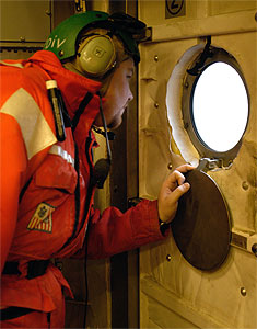
The morning sky was still dark when Healy's aviation crew
rolled an HH-65A Dolphin helicopter onto the flight deck. Jeremy Mathis
was already suited up in a survival suit, ready to climb aboard for
his trip to collect water samples at the mouth of the Yukon River.
With a blast of cold air, the Dolphin soared off into the predawn
light.
Jeremy Mathis is a graduate student working on his Ph.D. in chemical oceanography at the University of Miami. He has been been studying dissolved organic carbon (DOC) in the western Arctic with his advisor Dr. Dennis Hansell for the past two years. Jeremy answered these questions for me about his research and his trip to the Yukon today:
Jeremy, can you briefly describe just what dissolved organic
carbon is?
"That's a difficult question since no one really knows the answer right now! What we do know is that DOC is composed of large organic molecules. It's a byproduct of biological activity in the water--produced by the organisms that live in the water."
Why are you studying DOC, and why in the Arctic?
"One of the goals of the SBI program is to gain a greater understanding of the distribution and dynamics of dissolved organic carbon (DOC) in the western Arctic Ocean; particularly in its variability and transport over the Chukchi Sea shelf, adjacent slope, and basin. The role of DOC in the global carbon cycle is of considerable interest because the marine DOC pool is one of the major reservoirs of carbon in the biosphere. Given the strong seasonal signals (ice cover, light, biological production, etc.), and the impact of these on the carbon cycle, the Arctic Ocean remains vastly under sampled for DOC. We're here to change that."
Today you went to the mouth of the Yukon River to measure
DOC there. Why the Yukon?
"The Yukon River empties into the Bering Sea on the western coast of Alaska, just south of the settlement of Nome. The Yukon is an extremely large river and some of its waters come all the way from Canada. The river also provides drainage for much of the central interior of the state of Alaska. Because of the diversity of the waters that feed into the Yukon River and its tremendous length it has some very interesting physical properties. It literally carries thousands of pounds of sediments off of the continent of North America and into the Bering Sea. Some of the materials in these waters are very important to scientists studying the Arctic because strong currents carry much of the Yukon River outflow north, though Bering Strait and into the Arctic Ocean. River water in general is very high in DOC and during past cruises we have seen lower salinity waters that have high DOC values that we assumed to be Yukon River water in the sampling area in the Chukchi Sea."
How was your trip to the river? See any grizzlies?
"We left the ship at about 8:30 a.m and flew east for about 45 minutes to reach the mouth of the Yukon River. Once we made it to the river delta we followed it into the interior to get out of the range of the tides that could bring saltwater into the river and contaminate the samples that I would be taking. After flying about ten miles up river the pilots spotted a nice spot to set the helicopter down. The landscape was a mixture of marshy wetlands with scattered scrub brush, but the crew found a nice dry spot to land. Once on the ground I gathered water samples to take back to the Healy. The river was very murky and cold and the current was quite strong. While I collected the river samples the pilots and the flight mechanic explored the bank of the river. We saw several beavers swimming in the river as well as several species of birds. After collecting approximately 100 liters of water, we boarded the helicopter. We were on the ground for about an hour. We started our flight back flying low trying to spot more wildlife. We didn't see any bears, but we spotted three moose and many more beavers before reaching the river delta."
|
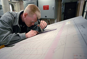 |
| Ryan Frazier plots future CTD stations on the chart of the Beaufort Sea. |
Click to enlarge
|
While Jeremy was on his trip to the Yukon River, the rest of
the science party tested all of the scientific equipment. The three
CTD watch teams, led by Tom Weingartner, Seth Danielson, and Ryan
Frazier, each had an opportunity to test their water
sampling skills. Maureen Taylor tested the Video Plankton Recorder
and Leopoldo Llinas the multi-net. The hub of scientific activity
on the ship is the main lab, where most of the science crew has set
up their computers. It's also the home of the "Board of Lies," where
the Chief Scientist posts the upcoming science plans. In order for
everyone to see the Board from their computers, anywhere on the ship,
a tiny digital camera has been set up to take a photo of the Board
every two minutes and post it to a website. Of course, sometimes the
mini-cam catches more than just the Board...
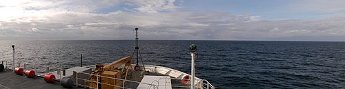
Tonight we will pass through the Bering Strait and enter the Arctic
Ocean's Chukchi Sea. Tomorrow will be the last day of preparation
before we arrive at our first scientific station north of Point Barrow,
Alaska.
Every day, in addition to these dispatches, I am posting eight photos
in the image gallery--don't
forget to check it out! And if you have questions or comments for
the science party, send us an email at arcticedge@whoi.edu.

|
Traducido al Espaþol por Andrea |
Aventura en Yukon
El cielo de la maþana estaba aun oscuro cuando la tripulacion del
helicoptero HH-65A Dolphin deslizo el helicoptero al heliodromo. Jeremy
Mathis estaba ya situado, con su traje de supervivencia preparado
para subir a bordo del helicoptero para su viaje en busca de muestras
de agua en estuario del rio Yukon. Con una rafaga de aire frio, el
Dolphin se introdujo dentro de la tenue luz.
Jeremy Mathis es un Licenciado que esta trabajando en su tesis de
oceanografia quimica en la Universidad de Miami. El ha estado estudiando
Carbono Organico Disuelto (COD) en la parte occidental del artico
con su director de tesis Dr. Dennis Hansell, durante los ultimos dos
aþos. Jeremy me respondio las siguientes preguntas sobre su investigacion
y su viaje a Yukon su:
Jeremy, ¢Podrias explicarme en que consiste el Carbono organico
disuelto?
Es una pregunta bastante dificil de responder, ya que nadie aun nadie
sabe la respuesta, lo que si sabemos es que el COD esta compuesto
por moleculas organicas complejas. Es un producto resultante de la
acticvidad biologica en el agua, producido por organismos que viven
en el agua.
¢Por que estas estudiando el COD en el Artico?
Uno de los objetivos del programa SBI es aumentar nuestro conocimiento
de distribuciµn y dinÃmica del COD en aguas del OcÕano êrtico, particularmente
la variabilidad y el transporte en la placa continental del mar de
Chukchi, el talud adyacente asÚ como la cuenca. El papel que juega
el COD en el ciclo global del carbono es considerablemente importante
ya que la cantidad de COD marino representa la mayor reserva de carbono
en la biosfera. Dadas las fuertes condiciones estacionales (formaciµn
de hielo, luz, producciµn biologica, etc...) y el impacto de estas
en el ciclo del carbono, no han sido ampliamente estudiadas. Estamos
aquÚ para eso.
Hoy fuiste al rio Yukon a medir COD. ¢Por que el rÚo Yukon?
El rio Yukon descarga en el mar de Bering, en la costa oeste de Alaska,
justo al sur del asentamiento de Nome. El rio Yukon es un rio extremadamente
largo donde algunos de sus afluentes provienen de Canada. Este rio
tambien drena muchas tierras del interior del estado de Alaska. Debido
a la diversidad de las aguas que nutren el rio Yukon y a su tremenda
longitud este tiene unas propiedades fisicas muy interesantes. Este
arrastra miles de kilos de sedimento continental de Norteamerica hasta
el mar de Bering. Algunos materials en estas aguas son muy importantes
para los estudios en el Artico dado que mucho es transportado por
la corriente hacia el norte a traves del estrecho de Bering hasta
el oceano Artico. El agua de los rios generalmente contiene mucha
cantidad de COD. En campaþas anteriores hemos observado aguas con
bajas salinidades que tenian gran contenido en COD,que asumimos que
eran aguas procedentes del rio Yukon aunque fueron muestreadas en
el mar de Chukchi.
¢Como fue el viaje al rÚo? ¢Visteis algun oso grizzly?
Dejamos el barco sobre las 8:30 am y volamos hacia el este cerca
de 45 minutos hasta que encontramos el estuario del rio Yukon. Una
vez encontramos el delta del rio lo seguimos hacia el interior para
evitar que el efecto de las mareas contaminara las muestras con agua
marina que iba a coger. DespuÕs de volar unas 10 millas rio arriba,
los pilotos encontraron una buena zona donde aterrizar el helicµptero.
El paisaje era una mezcla entre marismas y maleza dispersa, pero la
tripulacion encontro una buena zona seca donde aterrizar. Una vez
en tierra cogi las muestras de agua para llevarlas al Healy.
El rio era oscuro y frio y la corriente bastante fuerte. Vimos algunos
castores nadando asi como varias especies de pajaros. DespuÕs de coger
aproximadamente 100 litros de agua, volvimos al helicµptero. Estuvimos
en tierra cerca de una hora. Cuando volvimos volando bajo intentando
encontrar mas vida salvaje. No vimos osos pero pudimos ver tres alces
y mas castores antes de llegar al delta.
Mientras Jeremy estaba en su viaje hacia el rio Yukon, el resto del
grupo cientifico probaron los aparatos. Cada uno de los tres equipos
de obsevacion de CTD, liderados por Tom Weingartner, Seth Danielson
y Ryan Frazier, tuvieron la oportunidad de probar
su destreza en la toma de muestras. Maureen Taylor probo la videocamara
de plancton y Leopoldo Llinas la Multired. El centro de actividades
cientificas es el Laboratorio Principal donde muchos de los cientificos
han puesto sus ordenadores. Es tambien el lugar donde esta situada
la "Pizarra de las Mentiras", donde el cientifico jefe escribe
los planes del dia. Para que todo el mundo pueda ver la pizarra desde
sus ordenadores, en cualquier parte del barco, una pequeþa camara
digital hace una foto cada dos minutos y la envia a la pagina web.
Por supuesto algunas veces la minicamara coge otras
cosas en la pizarra
Esta noche pasaremos e Estrecho de Bering y entraremos en el mar de
Cuckchi, en el oceano Artico. Maþana sera el ultimo dia de preparacion,
antes de llegar a la primera estacion cientifica al norte del cabo
Barrow, Alaska. Todos los dias ademas de estos escritos, pondre 8
fotos en la galeria de imagines
Àno os olvideis de echarles un vistazo!, y si teneis alguna pregunta
o comentario para el grupo cientifico mandanos un email a: arcticedge@whoi.edu.
 Previous
Dispatch
Next Dispatch Previous
Dispatch
Next Dispatch

Back to Calendar
|
|