|
|
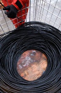 |
| 1,427 meters of
line are neatly coiled as the deepest mooring is retrieved. |
| Click
to enlarge |
Daily Update
Calendar
Dispatch 15 - September 24, 2003
By C. A. Linder
Weather conditions: Overcast skies, snow flurries, 15 kt
winds, 1-2 ft seas, air temperature 30°F
1,427 Meters of Wire
This morning the main lab was strangely quiet - the calm before
the storm. The preparations were finished,
now it was show time. Over the next few days John Kemp, Ryan Schrawder, Dan Torres, and the Healy boatswain's mates will be doing
a marathon redeployment operation - eight moorings taken out, eight
put back in. Almost the entire WHOI team will be involved in the
Beaufort Slope mooring array
in some way. Marshall Swartz will be calibrating the profiling CTD
instruments. Sarah Zimmermann wil be analyzing the past year's moored
profiler CTD data. Dan Torres will be helping with the recovery and deployment and analyzing the ADCP data. The
action started after breakfast with the deepest mooring.
Last year this mooring was particularly difficult to deploy because
of the shifting brash ice (read more about it in 2002
Dispatch 14). This year not a trace of ice was to be seen -
just gray waves. This took a load off of John Kemp's mind. The topmost
buoy had been outfitted with an avalanche
beacon last year, so that we could find it even if it popped
up under the ice. He was extremely pleased to not have to use it.
Once we hooked the top buoy with a
line through our A-frame, it was just a matter of pulling it all
in... All 1,400 meters of line - that's nearly a mile! It took over
two hours to bring it all on deck. The primary instrument on the
WHOI moorings is a moored profiler, a small robotic instrument that
climbs up and down the mooring wire twice a day. When this instrument
was retrieved it was immediately wheeled into the main lab, where
a waiting crew took it apart and began checking the data. After
several tense minutes, Ryan Schrawder made the diagnosis - 2,500
files - it worked perfectly! The little yellow profiler made its
last trip up the wire just 10 days ago! Bob Pickart was smiling
ear to ear, exclaiming "now that's what I call a mooring
deployment!" His elation was even more complete when the team brought
the second mooring in just before dinner and discovered that this
moored profiler had made its last profile as we released the anchor
today - two for two!
Mrs. Werner's class at the Morse Pond School came
up with these great questions about moorings. The leader of the
WHOI mooring team, John Kemp, helped
me with the answers.
Question: How deep down do the moorings go?
Answer: Since the moorings are spanning a submerged
"cliff," the depths vary. The deepest mooring is in 1,400
meters (4,593 ft) of water, and the shallowest is in a mere 57 meters
(188 ft) of water. The moorings are about 2-4 kilometers apart.
Click here
to see a diagram of what the moorings look like when they are all
deployed.
Question: How much do the moorings weigh?
Answer: This is a great question, since it has
two answers! Do you want to know how much it weighs when it's on
land, or in the water? It weighs a lot less when it's in the water,
due to the upward force of buoyancy from the floats. Since the mooring
is designed to operate in the water, all of the calculations are
made for water weight. The net upward force on the anchor is 1,000
pounds. The anchor has a water weight of 3,000 pounds. So, if you
were to weigh the mooring underwater, it would be 2,000 pounds.
 |
|
 |
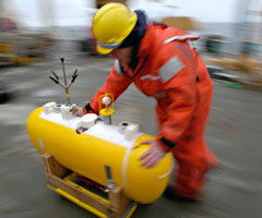
| Boatswain's mate
Scott Lussier pushes a moored profiler full of data back to
the science lab. |
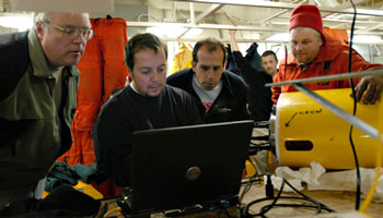
A nervous crowd
gathers around Ryan Schrawder as he determines how the profiler
performed on its year under the ice. |
| Click
to enlarge |
Click
to enlarge |
Question: How much do the moorings cost?
Answer: Since the moorings vary in size, they also
vary in cost. The smallest ones are the cheapest, and cost around
$50,000. The biggest one - the one we recovered today, costs around
$150,000. The grand total for the eight moorings is around $1,000,000.
This is one reason why we all have our fingers crossed when the mooring
release is activated. The other reason is the data. To Bob Pickart,
the data is worth more than the hardware. Hardware can be replaced,
but the data is priceless.
Question: Were they especially built for your
research?
Answer: Yes, these moorings were built specifically
for this project. John Kemp designed all of the moorings. The critical
instrument is a moored profiler (the yellow pill-shaped device shown
above left). WHOI scientists and engineers invented this instrument;
it is manufactured by McLane Instruments, Inc. It measures temperature,
salinity, and the currents. For the shallower moorings, a modification
was made to the moored profiler, making it much smaller and cheaper.
This "coastal moored profiler" only measures temperature,
salinity, and depth. This instrument was entirely designed and constructed
at WHOI.
Question: Do you attach a computer to the mooring
to get data or how do you get the data?
Answer: The data from the moored profilers is stored on a tiny hard drive built into a PCMCIA card. It's about the size of a credit card, and plugs directly into a laptop. It can hold 440 megabytes of data.
Tomorrow the marathon continues. If the moorings and weather cooperate
we could have three or even four more moorings on deck, hopefully
brimming with data.
 Previous
Dispatch Next Dispatch Previous
Dispatch Next Dispatch

Back to
Calendar
|