|
Daily Update
Calendar
Dispatch 09 - September 18, 2003
By C. A. Linder
Weather conditions: Overcast skies, snow flurries, 15 kt
winds, 1-2 ft seas, air temperature 30°F
24/7
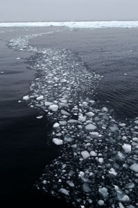
Our science operations have continued all day today as we make our
way south from last night's farthest north position. The winds have
died down, allowing thick layers of fog to form over the water.
Every so often a large raft of broken ice will appear on the horizon,
but the Healy hardly even slows down -- the floes are easily
thrust to the side as we cruise from station to station.
 |
|
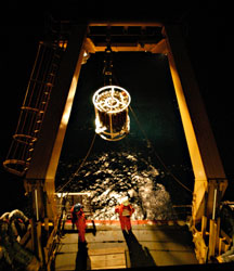
| CTD operations continue
24 hours a day, 7 days a week. This cast was brought aboard
at 1AM. |
| Click
to enlarge |
Question from Karen, Grade 6, Morse Pond School: What types
of things are you researching while you are there (besides temperature)
Answer: Chief Scientist Rebecca Woodgate answers
this important question about "why we're here":
"Our primary aim is to understand how the waters in the Chukchi
Sea get into the Arctic. The Chukchi Sea is shallow, only about
50 meters deep. (That's about 50 yards - think of a 50 yard dash
or half the length of a football field.) The Arctic Ocean just north
of it is over 3000 meters deep. (That's about 2 miles - how far
do you come to school?). About 1 million tons of water flow from
the Chukchi Sea into the Arctic every second. (That's on average
over the year - at any one time it could be more or less. Usually
it's more in summer and less in winter.) It's not like a huge waterfall,
as there is water in the Arctic already. It's more like turning
on a hose into a swimming pool.
We're trying to track the water from the Chukchi as it moves off
the shallow shelf (the Chukchi Sea) and into the deep Basin (the
Arctic). Hence the name of our project - Shelf-Basin Interactions
(visit the SBI Website). Some of
the questions we are trying to answer are:
- how much water flows off, where does it flow off the most (see
the three branches in our "best
guess" at the circulation)
- how does it flow off - in large currents ("rivers in the
sea"), or in "eddies" (larger versions of the whirlpools
you can make by moving a stick through the water - they are a few
inches in size, these are more like 5 miles across!).
We care about these questions for several reasons:
- because the water in the Chukchi Sea is very rich in nutrients
(food for all levels of marine life) and so it's important to know
how these waters move for the marine ecosystem.
- because these waters (for reasons I won't explain here) help preserve
the sea-ice floating in the Arctic, and that's important for the
climate of the world
- and also, because we don't understand yet how things flow up here
and we are curious to find out!
We try to answer these questions using - temperature and salinity
measurements, by investigating the chemistry of the water, by measuring
the direction of flow of the water. We do that both from measurements
we are taking now with the ship and also by looking at the information
collected by the moorings, the
instruments that have been out measuring since last summer."
Linnea from Mrs. Rodgers' class at the
Morse Pond School has a question about moorings.
Question: Are the moorings in danger of being hit
or damaged by sea animals like whales and/or polar bears?
Answer: David Leech has been working with moorings
for 34 years, so I asked him to answer this question:
"Polar Bears? No, these moorings are all subsurface and the
tops are deep enough to avoid even the deepest ice keels (we hope).
Whales and seals? Probably not because they navigate with accoustics,
sonar, and our flotation buoys are very good reflectors of acoustic
signals.
I don't know about walrus who dive down for clams and other amphipods
for food. Practically speaking, we have not seen any evidence of
our instruments having been bumped by these creatures. They are
so big that we would have probably seen broken parts."
To see diagrams of what the moorings look like, visit the instruments
page. The ice keels that David mentions are the biggest dangers
to the moorings. When pack ice forms it is smooth and uniform. However,
winds and currents cause them to smash into each other. This smashing
can cause the ice to form "pressure ridges" where the
plates meet -- these extend both high into the air and deep below
the surface. The underside of the ice can form into sharp jagged
edges known as ice keels. That's why the mooring instrumentation
is all far below the water surface.
I have received several weather-related questions from Morse
Pond School students.
Question from Taylor and Elliot (Mrs. Rodgers' class): Has
there been any unexpected weather? Any surprises?
Answer: So far, I am surprised at how uneventful
the weather has been. Coming from New England, I'm used to at least
three seasons in one day. Out here, the skies have been slate gray
overcast for probably 95% of the time. The temperature hasn't changed
more than 5 degrees since we left Barrow. That to me is surprising!
 |
|
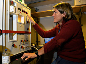
| Christina Courcier
measures the amount of dissolved salt in the seawater samples
using a salinometer. |
| Click
to enlarge |
Question from Mary (Mrs. Werner's class): What
is the coldest that it has ever gotten in the Arctic?
Answer: I contacted my friend Rick Krishfield back
at Woods Hole Oceanographic Institution for the answer to this one.
Rick is a veteran Arctic oceanographer. He deploys buoys in the
ice that measure the atmosphere and ocean. He tells me:
"As to the coldest temperatures: our buoys only recorded temperatures
down to -40°C (-40°F), and our systems usually saw winter
temperatures between -35 and -40°C. On the other hand, I found
winter air temperatures in the icepack down to about -56°C (-69°F)
at Russian NP-22 drifting station, and -55°C at Ice Island T-3.
In fact, the sea ice helps to moderate the cold temperatures, so
the coldest temperatures are usually found on land. I did a quick
web search and found the coldest temperature in the Northern Hemisphere
according to George H. Taylor, Climatologist: February 6th, 1933,
-90°F, Verkhoyansk, Siberia."
Rick's answer helps explain why Antarctica is so much colder than the Arctic. Can anyone guess the lowest recorded temperature on Antarctica? I'll provide the answer in the next dispatch.
Virgynia from Mrs. Werner's 6th grade class
at the Morse Pond School had this question.
Question:
What time do you go to bed?
Answer: I will be going to bed right after I finish
this dispatch! Usually that is around midnight or 1AM. Even while
I am sleeping, though, science operations are underway. The Healy's
Marine Science Technicians and the science party CTD watchstanders
work 24 hours a day, seven days a week. The day is divided into
different "watches" -- for example our CTD team is broken
into three watches. One group works from noon to 8PM, another works
from 8PM to 4AM, and a third works from 4AM to noon. That way every
minute of the day is covered. Everyone lends a helping hand at sea
-- the mooring technicians and even the dispatch writer pitch in
to help with CTDs!
Tomorrow the CTDs will continue as we make our way back to the Alaskan
coast. Carin Ashjian will also be deploying the Video Plankton Recorder to look at tiny organisms in the water column. Friday the 19th of September is also "Talk Like a Pirate Day" aboard the Healy, so stand by for some humorous photos... Arr!
 Previous
Dispatch Next Dispatch Previous
Dispatch Next Dispatch

Back to
Calendar
|