a
href="images/rsmovie.AVI">Drifter
Movie - 3 day tails
a
href="images/ge_movie_d28.kml">Alais
Reef Movie | |
OverviewNear-surface
GPS drifters in the Red Sea R. Limeburner, Y. Abualnaja, A.
Bower and R. Beardsley | | |
 |
|
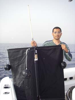
GPS drifter in air (photos courtesy of
Capt. Ahmed Shaker).

|
GPS drifter in water.
To see more photos of a GPS drifter deployment,
click here |
To see a movie of a GPS drifter
deployment (courtesy of Capt. Ahmed Shaker), click here |
| We
are deploying Davis-type satellite-tracked surface drifters in the Red
Sea during the semi-annual large-scale and
small-scale KAUST hydrographic cruises for three years 2010-2012 to
investigate the
near-surface Lagrangian currents in the Red Sea. These drifter
deployments will focus on the
small-scale KAUST coastal region, but drifters will also be deployed
over the entire eastern Red
Sea. The research cruises will collect important hydrographic and
biologic data on the Red Sea
ecosystem, but to date there have been very few direct measurements of
currents. Satellite-tracked
drifters provide a simple yet powerful tool to track the motion of
near-surface water on
time scales ranging from the tidal/inertial band to monthly and longer.
The deployment of drifters
on KAUST cruises will yield Lagrangian current data of intrinsic
interest and help place the other
KAUST measurements in the context of the regional circulation. The
combined drifter and
hydrographic data will provide the first detailed look at the
near-surface flow in this important
section of the Red Sea. In particular, the KAUST Lagrangian measurements
should identify
(a) the source region(s) of the coastal current flowing along the coral
reefs adjacent to the new
KAUST campus and marine science institute and (b) if organized
cross-shelf flows occur that
help create a gyre-like circulation over the shelf as suggested by
regional modeling.
Real-time Data
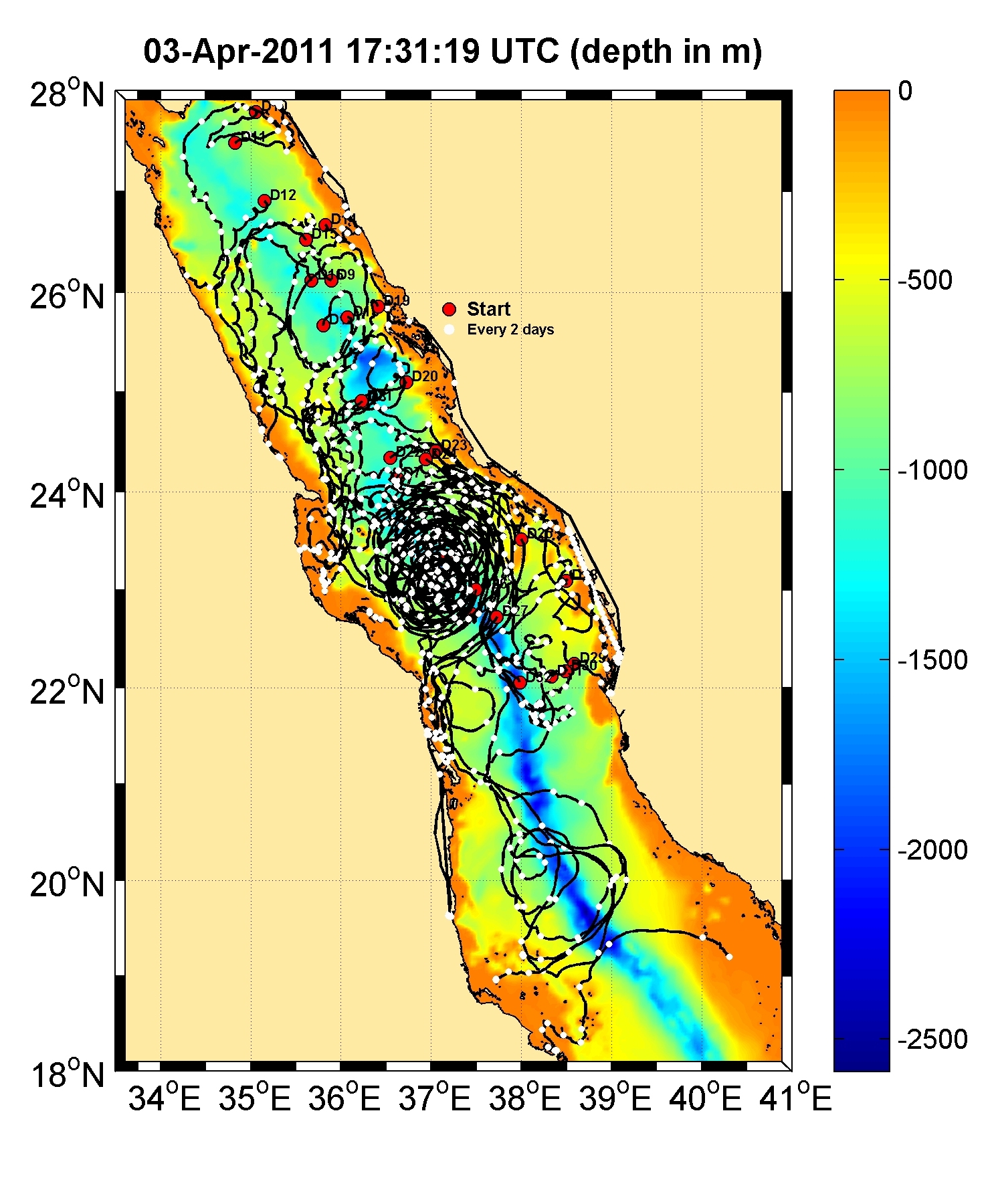
Figure 1. Most recent drifter tracks in the Red Sea. Solid
white circles every 2 days.
To view a movie of the drifter tracks with 3 day tails
click
here.
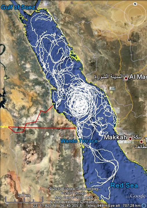
Figure 2. Drifters 2010
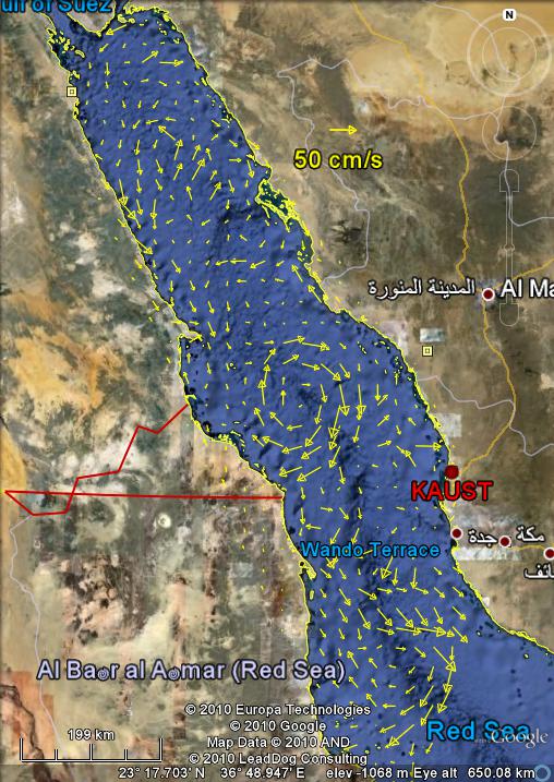
Figure 3. Mean surface currents march 17-30, 2010
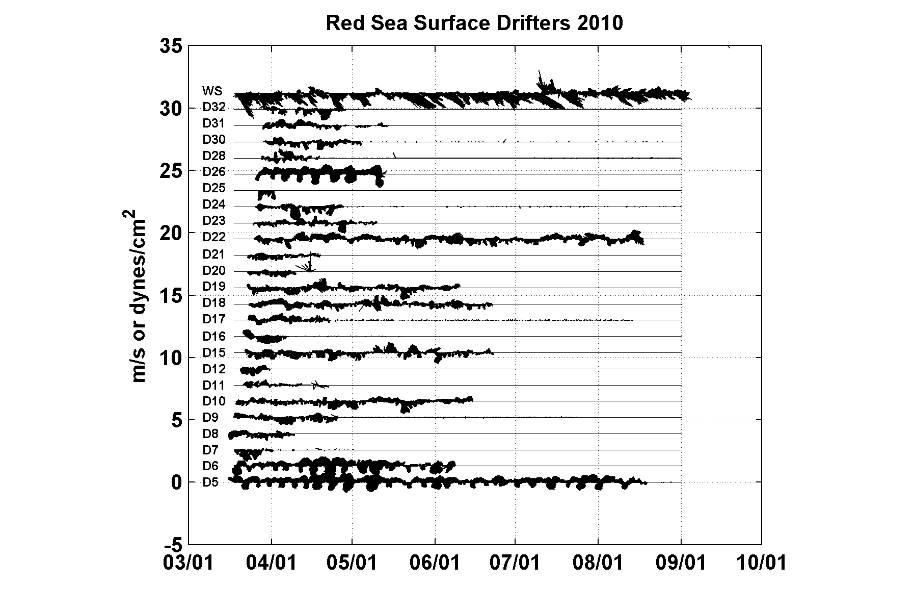
Figure 4. Vector stickplot 2010 of drifters and Kaust
wind stress dynes/cm^2 at the top
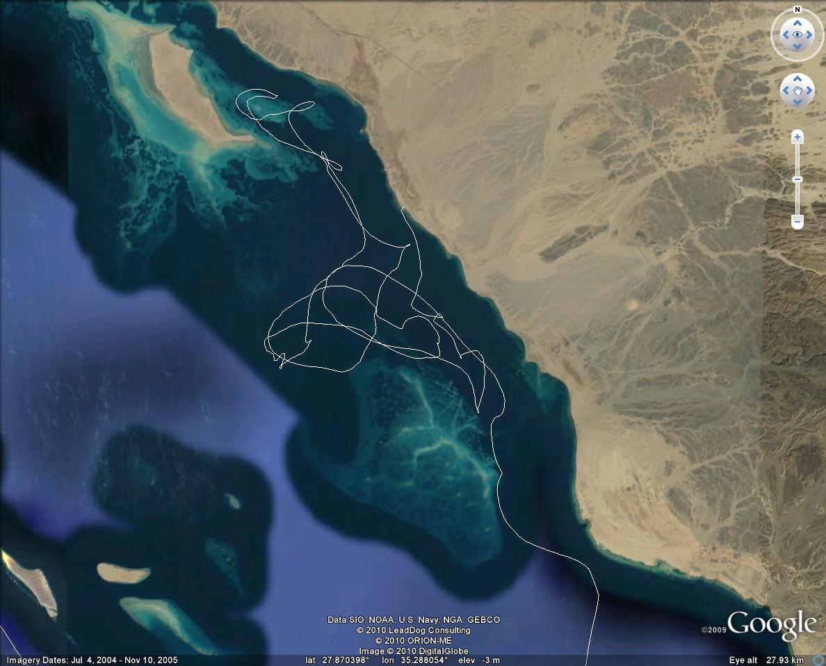
Figure 5. Drifter track inside a northern reef near Al
Muwaylih, Saudi Arabia.
KAUST 2010 Drifter Deployment Log
| ID |
Irridium # |
Date |
Time UTC |
Latitude D M |
Longitude D M |
| 5 |
637660 |
3/17/2010 |
0712 |
22 | 45.769 |
37 | 26.645 |
| 6 |
630070 |
3/17/2010 |
1100 |
23 | 20.862 |
37 | 10.371 |
| 7 |
531950 |
3/17/2010 |
1700 |
24 | 8.164 |
36 | 37.402 |
| 8 |
634060 |
3/17/2010 |
2306 |
24 | 54.460 |
36 | 14.460 |
| 9 |
634600 |
3/18/2010 |
1331 |
26 | 7.422 |
35 | 53.534 |
| 10 |
255690 |
3/18/2010 |
1222 |
27 | 46.974 |
35 | 3.647 |
| 11 |
633070 |
3/21/2010 |
0630 |
27 | 28.961 |
34 | 49.480 |
| 12 |
632080 |
3/21/2010 |
1855 |
26 | 54.436 |
35 | 8.944 |
| 13 |
632580 |
3/22/2010 |
0704 |
27 | 11.713 |
35 | 32.591 |
| 14 |
639060 |
3/22/2010 |
1851 |
26 | 40.490 |
35 | 49.370 |
| 15 |
525920 |
3/22/2010 |
2335 |
26 | 30.816 |
35 | 36.933 |
| 16 |
636070 |
3/23/2010 |
0315 |
26 | 7.010 |
35 | 40.550 |
| 17 |
638060 |
3/23/2010 |
0722 |
25 | 40.421 |
35 | 48.287 |
| 18 |
632070 |
3/23/2010 |
1155 |
25 | 45.399 |
35 | 4.150 |
| 19 |
638590 |
3/23/2010 |
1842 |
25 | 51.880 |
36 | 25.120 |
| 20 |
536940 |
3/24/2010 |
0647 |
25 | 6.242 |
35 | 43.417 |
| 21 |
636600 |
3/24/2010 |
1439 |
24 | 54.924 |
36 | 13.829 |
| 22 |
637070 |
3/25/2010 |
0644 |
24 | 20.477 |
36 | 32.441 |
| 23 |
536990 |
3/25/2010 |
0647 |
24 | 24.836 |
37 | 3.120 |
| 24 |
635070 |
3/25/2010 |
1604 |
24 | 19.800 |
36 | 56.001 |
| 25 |
634080 |
3/26/2010 |
2144 |
23 | 31.050 |
37 | 59.740 |
| 26 |
536930 |
3/27/2010 |
0851 |
23 | 3.188 |
37 | 29.981 |
| 27 |
158640 |
3/27/2010 |
1722 |
22 | 43.842 |
37 | 43.579 |
| 28 |
633080 |
3/28/2010 |
0659 |
23 | 5.150 |
38 | 29.150 |
| 29 |
635320 |
3/28/2010 |
2153 |
22 | 14.809 |
38 | 34.921 |
| 30 |
633580 |
3/29/2010 |
0457 |
22 | 9.942 |
38 | 29.859 |
| 31 |
532950 |
3/29/2010 |
1056 |
22 | 7.755 |
38 | 19.824 |
| 32 |
634070 |
3/29/2010 |
1121 |
22 | 2.994 |
37 | 59.239 |
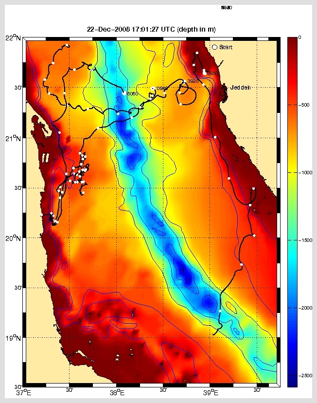
Figure 5. Drifter tracks 2008.
Sponsors
This project was funded by King Abdullah University of Science and
Technology (KAUST) by Award Nos. USA 00002 and KSA 00011.

Last updated: April 4, 2011
|