|
|
 |
Daily Update
Calendar
Dispatch 22 - August 5, 2002
By C.A. Linder
Weather conditions: intermittent snow, overcast skies, winds 15-20 knots from the SW, seas 1 ft., air temperature 31° F.
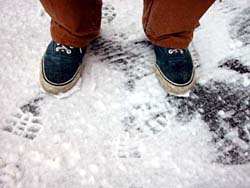
Snow Day
I must admit, it’s a little bizarre to see big fat snowflakes in the middle of summer! This is the first day it has snowed more than just a flurry; the snow was sticky and wet, and we got about an inch of accumulation on the decks. Gusty winds also whipped around the ship and kept the temperature in the bone-chilling range all day. It appears that the Arctic summer has quickly passed and we are now in Arctic autumn!
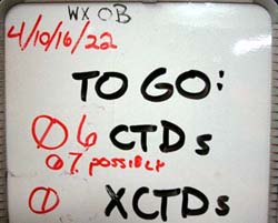
The freezing temperatures didn’t stop the CTD crew, though. Large gaps in the ice enabled us to push ahead and finish another group of stations across the Chukchi shelfbreak. We supplemented the regular CTD casts with the remainder of the XCTD probes, allowing us to keep the station spacing at a narrow 2.5 kilometers.
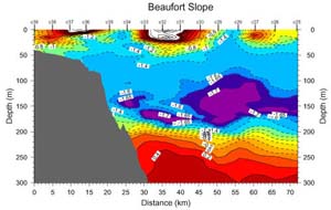
In yesterday’s dispatch we looked at a single CTD profile. Today let’s take a look at a section - this is basically a group of profiles arranged in a line. This allows us to look at a cross-section of the ocean, like looking through the side of a fish tank. Instead of looking at the scaly denizens of the deep, we’re looking at numbers. These numbers, the water temperature and salinity, tell us a lot about where water has come from, where it’s going, and how it’s changing. The sample section to the left was taken across the Beaufort shelf and slope. The locations of the CTD casts are labeled along the top of the plot (c39, c38, etc). The color of the shading indicates the temperature of the water (purple/blue is colder water, and red is warmer water). Remember yesterday we found a mass of warmer water between 300 and 500 meters... If you look at this plot you can see the same thing - the orange-red colored mass of water is the Atlantic layer. The most interesting feature in the section, however, is the blob of very cold (purple colored) water at 150 meters depth between stations c27 and c30.
We surmise that this blob of water (also called a “lens”) originally came from along the shelf, and has traveled out into the deep ocean. If you’re wondering - “how did it get there?” then you’re not alone - so are we! That’s why the WHOI moorings are placed so closely together in a section across the Beaufort shelfbreak.
They will collect a snapshot just like this one four times per day for an entire year. When we get this data back, we will hopefully be able to watch these lenses forming and moving out into the deep Arctic basin. That’s one of the main objectives of the WHOI team.
One benefit of having such a small but focused science party is the ability to change our plans quickly and easily! For example, the section we finished tonight was never in the original plan. Since we finished our moorings ahead of schedule, we decided to revisit the Chukchi shelfbreak. Even that plan has been modified - we cut out the last two deep stations on this section so we can do more CTDs to our southeast. We never thought we’d be able to do this many CTD casts, but we’re taking advantage of the great ice conditions while we can!
 Previous Dispatch
Next Dispatch Previous Dispatch
Next Dispatch

Back to Calendar
|
|