|
|
 |
Daily Update
Calendar
Dispatch 16 - July 30, 2002
By C.A. Linder
Weather conditions: clear skies, winds 12 knots from the SE, calm seas, air temperature 36° F.
Around the Clock
Another chilly, clear morning greeted us today. On days like this, the ice and water act like giant mirrors, reflecting the sunlight. It’s difficult to walk around outside the ship without sunglasses on - everywhere you look it feels like you’re staring into the sun! We have left our large “open lake” behind, but there are plenty of open water areas, and we’re feeling very fortunate - it appears that Mother Nature has given us another good day to get a lot of oceanography done.
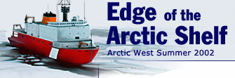
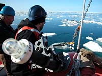
Our science operations are now running smoothly around the clock. At night we do CTD casts, and during the day we deploy the moorings. Today we put two moorings into the water, the third and fourth along this WHOI line. Unlike the last two moorings, these shallower ones have ADCPs instead of traditional mechanical current meters. ADCPs use high frequency sound energy to measure the currents. These shallower moorings also have a Coastal Moored Profiler, an instrument which travels up and down the mooring line to measure the temperature and salinity four times per day. This is the first time these coastal profilers have ever been used. In fact, they were designed for this particular experiment!
We have also managed to get the XCTD system working, which is a great relief. These small probes are quickly and easily launched from the fantail of the ship with a small hand-held launcher. In a matter of minutes we can see a vertical profile of temperature and salinity versus depth. The tiny probe, which looks like a miniature torpedo, sends the data back to the ship via a very thin copper wire, which breaks when the line runs out. In contrast to the large, unwieldy CTD package, we don’t need to find a large open water area, nor do we need to stop the ship for more than a few minutes. So why don’t we always use XCTDs? Well, one reason is that we can’t collect water samples, so there is no way to verify the salinity data or determine the water nutrients. The other reason is that they can only be used in water shallower than 1100 meters.
 |
|
|
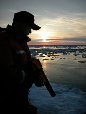
John Kemp (left) and Dan Torres (right) wait for the OK to put the final buoy into the water. |
|
Click to enlarge |
We are using these XCTDs to “fill in the gaps” along our line of CTD stations. This close spacing allows us to see very small-scale oceanographic features. For example, what if you ask two people what the weather is like - one person in California and one in Massachusetts. If they both say “sunny and warm,” then all you can assume is that between California and Massachusetts, the weather is beautiful. While this might be the case, most likely you would be missing a lot of clouds and rain that are between your two observers. The only way to improve your “picture” of the weather is to get more observers. The same is true for the ocean. Think of these CTDs and moorings as robotic observers of the ocean temperature, salinity, and currents. If you space them far apart, say 20 kilometers, then you won’t be able to see swirls and bends in the ocean currents (called “eddies” and “meanders”) which may measure 5-10 kilometers across. That’s why the WHOI mooring array and CTD casts are spaced so closely along the Beaufort slope - we are hoping to be able to “see” for the first time these smaller scale oceanographic features.
Have a question about moorings, XCTDs, moorings, or sundogs? Send me your Arctic questions and I’ll try to find the answers: arcticedge@whoi.edu.
 Previous Dispatch
Next Dispatch Previous Dispatch
Next Dispatch

Back to Calendar
|
|