|
|
 |
|
 |
|
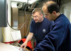
Captain Mackenzie (left) and Bob Pickart (right) discuss Plan B. |
|
Click to enlarge |
 |
|
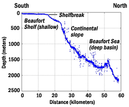
This plot shows the contour of the bottom as we progressed northward on July 25th. Bob Pickart deemed that the slope was too steep here to effectively deploy his moorings. |
|
Click to enlarge |
 |
|
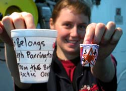
Sarah Thornton shows the crushing effects of 3000 feet of water. |
|
Click to enlarge |
 |
|
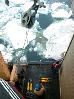
John Kemp successfully tested all of his acoustic releases (yellow cylinders on deck) today. |
|
Click to enlarge |
Daily Update
Calendar
Dispatch 12 - July 26, 2002
By C.A. Linder
Weather conditions: intermittent snow flurries, partly cloudy skies, calm winds and seas, air temperature 34° F.
Plan B
You’ve gotta have a Plan B. This morning, Bob Pickart pondered his choices. We had just completed our depth survey of the Beaufort slope, and when Bob plotted up the data he got a shock. For many months he has been planning this cruise, and based his plans on the best digital bathymetry (depth) data available. What he found was a much steeper slope than the charts indicated! He was faced with a tough choice. He could either stick with the original plan, which was to begin putting in the moorings immediately, starting with the deepest and working back towards the shelf. Or, he could strike off 40 miles to the west where the slope is shallower. This could be costly, though - we would lose about two more precious days transiting to the start of the new line and doing another survey. Even more troubling, the bathymetry is very complex to the west, offering no obvious choice as to where to position the array in order to address the same scientific questions. The alternative - placing the moorings close together on this steep slope - was simply unacceptable. Due to the difficulty in finding open water areas in the ice, it is much safer to deploy the moorings on the shallower slope where we have a bigger margin of error in placement.
We enjoyed a refreshing dose of sunlight today as we bobbed and drifted along with the ice. The ship was strangely silent, her engines shut down for repairs to the port shaft, which drives the leftmost of the three propellers. John Kemp took advantage of this down time to test his acoustic releases. They can be tested on deck, but John doesn’t take any chances. He wanted to see them work underwater. They have had quite a trip from Woods Hole, Massachusetts to the Beaufort shelf, and anything could have happened to the sensitive electronic components. If there’s one instrument you want to work on your mooring, it’s the one that allows you to get your mooring back! Since the releases were going down to 3000 feet, it was also an excellent time to create some homemade oceanographic souvenirs... Long ago, oceanographers discovered that ordinary styrofoam cups, when subjected to the great pressures of the ocean depths, will compress into tiny shrunken thimbles (and you can still read the writing and decorations!). Once the word got out, many of the crew started decorating cups, and John’s acoustic releases carried a precious laundry bag of cups along on every trip to the bottom.
Here are two questions from our website readers:
Q: Great website, especially the bit about the wildlife. Isn’t a group of walruses refered to as an “ugly?” Thanks and keep up the good work!!! A D L
A: Thanks for the email A D L! You got me! We searched long and hard for this answer before I posted the dispatch about walruses. Aaron Morello actually emailed his wife Catherine, and she also came up with the term "ugly of walruses" but I just didn’t believe it. Looks like it’s true - if you can have a “murder of ravens” why not an "ugly of walruses"!
Q: I continue to immensely enjoy the daily updates by Chris Linder. They are interesting and educational. The photos are excellent - I can almost imagine standing on the ship and viewing everything. I would like to thank Tom Weingartner for answering a question I had sent in last week. I have a couple of other questions: - What affects how fast currents flow? - Does the steepness of the shelfbreak have a significant impact on the speed or direction of the currents flowing along it? Thank you. Sincerely, George
A: Chief Scientist Tom Weingartner answers: Current speeds are affected by many processes including winds and changes (gradients) in water density (which depend on the temperature and salinity properties of the water). As a general rule regions where there are large horizontal gradients in water properties are often associated with swift currents. (Of course you are familiar with this in the atmosphere when an atmospheric front passes by. Winds are typically swifter in a front and as the front passes the air temperature and/or rainfall changes.) There are fronts in the ocean as well and these often form or get trapped over areas where the bathymetry changes rapidly - such as a shelfbreak. The steeper the shelfbreak the (generally) faster the current. In the Northern Hemisphere the flow along a shelfbreak is such that shallow water (the shelf) is on your right as you look in the direction of the flow.
 Previous Dispatch
Next Dispatch Previous Dispatch
Next Dispatch

Back to Calendar
|
|