|
|
 |
Daily Update
Calendar
Dispatch 08 - July 22, 2002
By C.A. Linder
Weather conditions: overcast skies and light snow flurries, wind 8 kts from NE, calm seas, air temperature 31° F.
Earthquake?
I awoke with a start. The ship shuddered violently; it felt like a giant hand was shaking us. I heard another sound, like distant thunder, or someone hitting a piece of sheet metal with a hammer. The ship seemed to roll slightly, then right itself. A whole host of strange noises continued through the night. We listened to cracks as the large ice floes broke under the ship’s weight, and squeals as the jagged broken slabs scraped across the ship’s sides.
 |
|
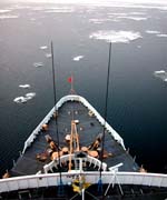
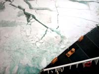
| Thick pack ice
buckles and cracks under the Polar Star’s weight. |
| Click
to enlarge |
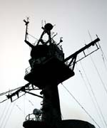
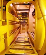
I found out over breakfast that we had hit some thick multi-year ice last night during the CTD section. Instead of burning the extra fuel necessary to blast through this very hard ice, the Captain opted to utilize the open water areas (called “leads”) that lay slightly off of our track. Matt Walker, the Operations Officer, suggested that I take a tour of the “aloft conn,” (aloft conning tower) where the crew drives the ship when breaking heavy ice. To get there you crawl up a very narrow enclosed ladderway, until you arrive at the top of the tower, over a hundred feet above the decks below. The view is incredible, but the tower wasn’t built with aesthetics in mind! From here the crew can scout out the open leads far ahead, and save a considerable amount of fuel by driving the ship around the largest chunks of ice.
Today was a day of rest for most of the science party. Having completed the south-north section of CTDs overnight, we are now breaking through the pack ice heading southeast to Barrow Canyon, the site of the fourth and final UW/UAF mooring. For John Kemp, the WHOI mooring expert and veteran of an unbelievable number of cruises, it was a great time to get ahead. I found John in one of the science labs, where he was assembling the last of the avalanche beacons for the WHOI Beaufort slope moorings. Next year, the moorings will need to be brought up from the ocean so that we can retrieve the oceanographic data. First, we will need to find the exact spot where they were dropped. GPS technology allows us to find the spot within a few feet. Then, a sound source is placed in the water and a coded pinging “message” is sent. The acoustic release, placed just above the mooring anchors, “hears” this sequence, and releases the anchor. Then the mooring floats to the surface, where scientists can bring it on deck and see their long-anticipated data!
However, this is all complicated in the Arctic by the pack ice. Although the ship will attempt to break up and clear a large pool, it is still possible for the mooring to come up underneath thick ice. In this case, the beacon will activate, and the mooring crew will be able to find their precious instruments. This is the same kind of device that backcountry skiers and hikers use in order to be found if they are covered by an avalanche. They aren’t, however, sold in underwater pressure housings. Oceanographers often have to get creative to get the job done.
Send your questions about Arctic oceanography and shipboard life to
arcticedge@whoi.edu. I’ll
do my best to find the answers!
 Previous Dispatch
Next Dispatch Previous Dispatch
Next Dispatch

Back to Calendar
|
|